


EtampespmS120917

fmg
User

Length
11.3 km

Max alt
145 m

Uphill gradient
167 m
Km-Effort
13.5 km

Min alt
67 m

Downhill gradient
167 m
Boucle
Yes
Creation date :
2017-06-01 00:00:00.0
Updated on :
2017-06-01 00:00:00.0
2h58
Difficulty : Unknown

FREE GPS app for hiking
 SityTrail
IGN / Geographical institutes
SityTrail Plus
The world is yours!
About
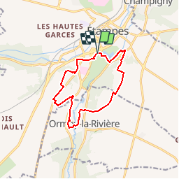
Trail Walking of 11.3 km to be discovered at Ile-de-France, Essonne, Étampes. This trail is proposed by fmg.
Positioning
Country:
France
Region :
Ile-de-France
Department/Province :
Essonne
Municipality :
Étampes
Location:
Unknown
Start:(Dec)
Start:(UTM)
437603 ; 5364105 (31U) N.
Comments