


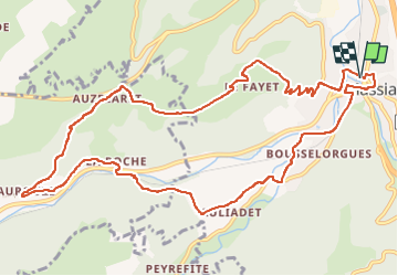
Massiac_Chateau_Aurouze

jagarnier
User GUIDE


4h00
Difficulty : Medium

FREE GPS app for hiking
 SityTrail
IGN / Geographical institutes
SityTrail Plus
The world is yours!
About
Trail Walking of 13.1 km to be discovered at Auvergne-Rhône-Alpes, Cantal, Massiac. This trail is proposed by jagarnier.
Description
Aux portes du Cézalier, cette randonnée escarpée conduit aux ruines d'un des nombreux châteaux qui contrôlaient la vallée de l'Alagnon.
Après quelques passages physiques on atteint le plateau volcanique avec ses orgues sous lesquels s'ouvrent les grottes que fréquentaient les chasseurs de rennes du magdalénien.
Photos

Positioning
Comments