


sentier roman RENNES - MONT SAINT MICHEL_backup_backup

MoulinPierrick
User

Length
3.9 km

Max alt
11 m

Uphill gradient
12 m
Km-Effort
4 km

Min alt
4 m

Downhill gradient
8 m
Boucle
No
Creation date :
2017-03-07 00:00:00.0
Updated on :
2017-03-07 00:00:00.0
54m
Difficulty : Easy

FREE GPS app for hiking
 SityTrail
IGN / Geographical institutes
SityTrail Plus
The world is yours!
About
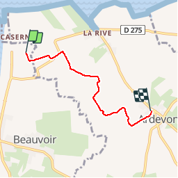
Trail Walking of 3.9 km to be discovered at Normandy, Manche, Beauvoir. This trail is proposed by MoulinPierrick.
Description
Maison de la baie ( parking navettes ) - ARDEVON
Positioning
Country:
France
Region :
Normandy
Department/Province :
Manche
Municipality :
Beauvoir
Location:
Unknown
Start:(Dec)
Start:(UTM)
610096 ; 5385428 (30U) N.
Comments