


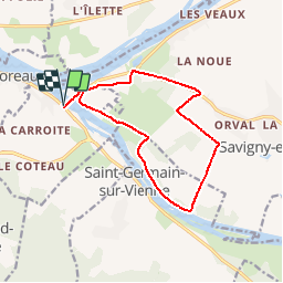
LA VOIE ROMAINE

laoj
User

Length
12.8 km

Max alt
42 m

Uphill gradient
94 m
Km-Effort
14.1 km

Min alt
27 m

Downhill gradient
95 m
Boucle
Yes
Creation date :
2017-03-07 00:00:00.0
Updated on :
2017-03-07 00:00:00.0
49m
Difficulty : Easy

FREE GPS app for hiking
 SityTrail
IGN / Geographical institutes
SityTrail Plus
The world is yours!
About
Trail Cycle of 12.8 km to be discovered at Centre-Loire Valley, Indre-et-Loire, Candes-Saint-Martin. This trail is proposed by laoj.
Description
PETITE BALLADE EN FAMILLE AU NORD DE LA VIENNE
AUCUNE DIFFICULTE CIRCUIT PLAT !
Positioning
Country:
France
Region :
Centre-Loire Valley
Department/Province :
Indre-et-Loire
Municipality :
Candes-Saint-Martin
Location:
Unknown
Start:(Dec)
Start:(UTM)
278716 ; 5232590 (31T) N.
Comments