


-- signes - col des glacieres - le latay.gpx

georgein
User
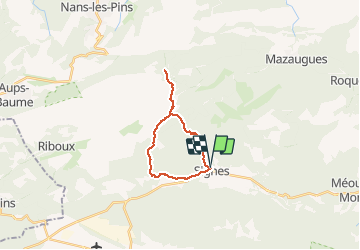

Length
18.9 km

Max alt
867 m

Uphill gradient
711 m
Km-Effort
28 km

Min alt
347 m

Downhill gradient
719 m
Boucle
Yes
Creation date :
2019-08-04 09:23:07.246
Updated on :
2020-01-31 20:34:01.108
--
Difficulty : Unknown

FREE GPS app for hiking
 SityTrail
IGN / Geographical institutes
SityTrail Plus
The world is yours!
About
Trail Walking of 18.9 km to be discovered at Provence-Alpes-Côte d'Azur, Var, Signes. This trail is proposed by georgein.
Positioning
Country:
France
Region :
Provence-Alpes-Côte d'Azur
Department/Province :
Var
Municipality :
Signes
Location:
Unknown
Start:(Dec)
Start:(UTM)
732241 ; 4797276 (31T) N.
Comments