


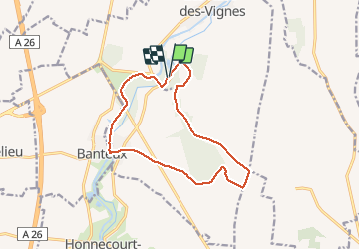
Vaucelles 12.3Km Dén P 150m

alain62rando
User


2h14
Difficulty : Easy

FREE GPS app for hiking
 SityTrail
IGN / Geographical institutes
SityTrail Plus
The world is yours!
About
Trail Walking of 12.3 km to be discovered at Hauts-de-France, Nord, Les Rues-des-Vignes. This trail is proposed by alain62rando.
Description
Départ parking Abbaye de Vaucelles
Belle randonnée en sous bois puis en plaine pour rattraper le canal de St Quentin (l'Escault)et longer celui-ci sur un chemin herbeux jusqu’au retour à l'Abbaye de Vaucelles
Positioning
Comments