


Roquefort les pins Villeneuve Antibes Tamarins Roquefort

GrouGary
User
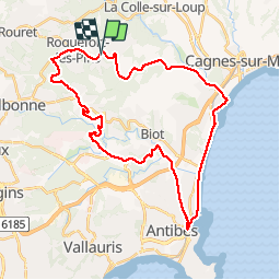

Length
37 km

Max alt
215 m

Uphill gradient
551 m
Km-Effort
45 km

Min alt
2 m

Downhill gradient
542 m
Boucle
Yes
Creation date :
2017-03-11 00:00:00.0
Updated on :
2017-03-11 00:00:00.0
3h17
Difficulty : Medium

FREE GPS app for hiking
 SityTrail
IGN / Geographical institutes
SityTrail Plus
The world is yours!
About
Trail Mountain bike of 37 km to be discovered at Provence-Alpes-Côte d'Azur, Maritime Alps, Roquefort-les-Pins. This trail is proposed by GrouGary.
Description
circuit routes et pistes
Positioning
Country:
France
Region :
Provence-Alpes-Côte d'Azur
Department/Province :
Maritime Alps
Municipality :
Roquefort-les-Pins
Location:
Unknown
Start:(Dec)
Start:(UTM)
343932 ; 4836301 (32T) N.
Comments