


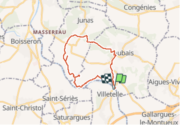
RP30 VILLETELLE - JUNAS - AUBAIS - VILLETELLE

jeff66
User


2h40
Difficulty : Medium

FREE GPS app for hiking
 SityTrail
IGN / Geographical institutes
SityTrail Plus
The world is yours!
About
Trail Walking of 14 km to be discovered at Occitania, Hérault, Villetelle. This trail is proposed by jeff66.
Description
RP30 VILLETELLE - moulin de Carrière - chemin de Peysal - DFCI C42 - la Roque d'Aubais - la plaine de la Roque - poste gaz - JUNAS - chemin du Grès - le Frigoulier - pont des Combes - Ch. de la font de Mon RAU - Ch. du pin - la tuilerie haute - piste DFCI C39 - AUBAIS - ch. du Chassaret - Ch. du MAS de la Vieille - ch. de Junas - MAS Begon - ch. du moulin à vent - RD12 - ch. du moulin Carrière - le vidourle - VILLETELLE - stade - le 11.03.2017
Positioning
Comments