


pic de lary

epablo
User
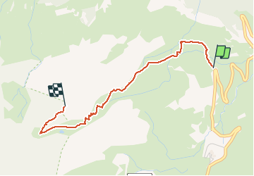

Length
3 km

Max alt
2374 m

Uphill gradient
640 m
Km-Effort
9.4 km

Min alt
1724 m

Downhill gradient
0 m
Boucle
No
Creation date :
2017-03-12 00:00:00.0
Updated on :
2017-03-12 00:00:00.0
2h10
Difficulty : Unknown

FREE GPS app for hiking
 SityTrail
IGN / Geographical institutes
SityTrail Plus
The world is yours!
About
Trail Other activity of 3 km to be discovered at Occitania, Hautespyrenees, Gavarnie-Gèdre. This trail is proposed by epablo.
Description
10 Mars 2017
Ski de rando TAG
Gavarnie
Positioning
Country:
France
Region :
Occitania
Department/Province :
Hautespyrenees
Municipality :
Gavarnie-Gèdre
Location:
Gavarnie
Start:(Dec)
Start:(UTM)
743060 ; 4735905 (30T) N.
Comments