


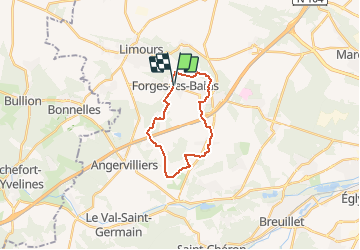
2017-03-23 Forge les Bains 17 km prévu

Lucquiaud
User

Length
17 km

Max alt
155 m

Uphill gradient
198 m
Km-Effort
19.6 km

Min alt
79 m

Downhill gradient
200 m
Boucle
Yes
Creation date :
2018-09-15 15:04:36.47
Updated on :
2018-09-15 15:04:36.551
4h17
Difficulty : Easy

FREE GPS app for hiking
 SityTrail
IGN / Geographical institutes
SityTrail Plus
The world is yours!
About
Trail Walking of 17 km to be discovered at Ile-de-France, Essonne, Forges-les-Bains. This trail is proposed by Lucquiaud.
Positioning
Country:
France
Region :
Ile-de-France
Department/Province :
Essonne
Municipality :
Forges-les-Bains
Location:
Unknown
Start:(Dec)
Start:(UTM)
433601 ; 5386577 (31U) N.
Comments