


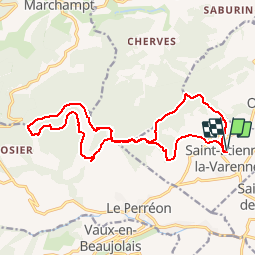
Saint-Etienne-La-Varenne (17 km - D. 630 m)

Thomasdanielle
User


5h52
Difficulty : Very difficult

FREE GPS app for hiking
 SityTrail
IGN / Geographical institutes
SityTrail Plus
The world is yours!
About
Trail Walking of 17.4 km to be discovered at Auvergne-Rhône-Alpes, Rhône, Saint-Étienne-la-Varenne. This trail is proposed by Thomasdanielle.
Description
Le 10/10/2016 - 17,3 km - D. 630 m
Départ parking Eglise, prendre la route à droite, à la croix des rameaux prendre à droite la petite route qui monte vers la forêt puis à la bifurcation prendre le chemin qui monte sur la droite dans la forêt, panneau "le trou du loup".
Positioning
Comments