


sud_backup

les randos d'Olivier
partout a pied et en moto
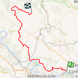

Length
108 km

Max alt
174 m

Uphill gradient
1455 m
Km-Effort
128 km

Min alt
19 m

Downhill gradient
1500 m
Boucle
No
Creation date :
2019-01-14 09:43:27.749
Updated on :
2019-01-14 09:43:27.892
3h00
Difficulty : Unknown

FREE GPS app for hiking
 SityTrail
IGN / Geographical institutes
SityTrail Plus
The world is yours!
About
Trail Walking of 108 km to be discovered at Ile-de-France, Yvelines, Évecquemont. This trail is proposed by les randos d'Olivier.
Positioning
Country:
France
Region :
Ile-de-France
Department/Province :
Yvelines
Municipality :
Évecquemont
Location:
Unknown
Start:(Dec)
Start:(UTM)
422426 ; 5429699 (31U) N.
Comments