


Denice´ - 2 - (69)

Thomasdanielle
User

Length
11.5 km

Max alt
670 m

Uphill gradient
443 m
Km-Effort
17.4 km

Min alt
260 m

Downhill gradient
443 m
Boucle
Yes
Creation date :
2017-03-21 00:00:00.0
Updated on :
2019-02-28 10:59:19.113
3h17
Difficulty : Very easy

FREE GPS app for hiking
 SityTrail
IGN / Geographical institutes
SityTrail Plus
The world is yours!
About
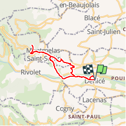
Trail Walking of 11.5 km to be discovered at Auvergne-Rhône-Alpes, Rhône, Denicé. This trail is proposed by Thomasdanielle.
Description
11,15 km
Photos
 - Photo 1")
 - Photo 2")
 - Photo 3")
 - Photo 4")
 - Photo 5")
 - Photo 6")
 - Photo 7")
 - Photo 8")
Positioning
Country:
France
Region :
Auvergne-Rhône-Alpes
Department/Province :
Rhône
Municipality :
Denicé
Location:
Unknown
Start:(Dec)
Start:(UTM)
627448 ; 5095527 (31T) N.
Comments