


LE CLOS GUÉ

laoj
User
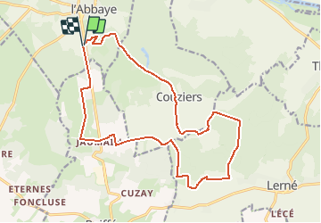

Length
18.8 km

Max alt
117 m

Uphill gradient
281 m
Km-Effort
23 km

Min alt
56 m

Downhill gradient
280 m
Boucle
Yes
Creation date :
2017-03-21 00:00:00.0
Updated on :
2017-03-21 00:00:00.0
1h29
Difficulty : Easy

FREE GPS app for hiking
 SityTrail
IGN / Geographical institutes
SityTrail Plus
The world is yours!
About
Trail Mountain bike of 18.8 km to be discovered at Pays de la Loire, Maine-et-Loire, Fontevraud-l'Abbaye. This trail is proposed by laoj.
Description
DÉPART ET ARRIVÉE STADE DE FONTEVRAUD
BALLADE AU SUD DE FONTEVRAUD PLUS VTC QUE VTT MALGRÉ QUELQUES PASSAGES TECHNIQUES.
Positioning
Country:
France
Region :
Pays de la Loire
Department/Province :
Maine-et-Loire
Municipality :
Fontevraud-l'Abbaye
Location:
Unknown
Start:(Dec)
Start:(UTM)
276194 ; 5228547 (31T) N.
Comments