


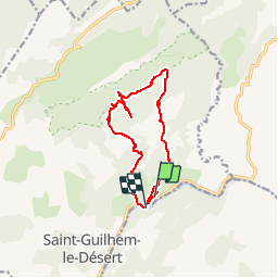
Barrage Belbezet - Mas de l'Estagnol - Roc de la Vigne - Mas de l'Arbousier

vertygo
User

Length
12.1 km

Max alt
647 m

Uphill gradient
705 m
Km-Effort
22 km

Min alt
69 m

Downhill gradient
738 m
Boucle
No
Creation date :
2017-03-22 00:00:00.0
Updated on :
2017-03-22 00:00:00.0
4h27
Difficulty : Medium

FREE GPS app for hiking
 SityTrail
IGN / Geographical institutes
SityTrail Plus
The world is yours!
About
Trail Walking of 12.1 km to be discovered at Occitania, Hérault, Saint-Guilhem-le-Désert. This trail is proposed by vertygo.
Description
voir des photos sur www.vertygo.org
https://goo.gl/photos/wLbgubhza5aU22J89
Positioning
Country:
France
Region :
Occitania
Department/Province :
Hérault
Municipality :
Saint-Guilhem-le-Désert
Location:
Unknown
Start:(Dec)
Start:(UTM)
545770 ; 4843812 (31T) N.
Comments