![](/images/other/stat-length.png)
![Trail Walking Libin - Entre Lesse et Lomme_30-A - Anloy - Photo](https://media.geolcdn.com/t/1900/400/ext.pjpeg?maxdim=2&url=https%3A%2F%2Fmedia.geolcdn.com%2Ff%2Fc8c5f752-40ef-4cf3-9ad8-e33f814a310b.jpg)
Entre Lesse et Lomme_30-A - Anloy
La Grande Forêt de Saint-Hubert
Randonnées de la Grande Forêt de Saint-Hubert GUIDE+
![Length](/images/other/stat-length.png)
Length
2.1 km
![Max alt](https://static1.geolcdn.com/siteimages/upload/files/1508320355ic_sort_altitude_max_24dp.png)
Max alt
408 m
![Uphill gradient](https://static1.geolcdn.com/siteimages/upload/files/1508320355ic_sort_den_pos_24dp.png)
Uphill gradient
32 m
![Km-Effort](/images/other/stat-length.png)
Km-Effort
2.6 km
![Min alt](https://static1.geolcdn.com/siteimages/upload/files/1508320355ic_sort_altitude_min_24dp.png)
Min alt
367 m
![Downhill gradient](https://static1.geolcdn.com/siteimages/upload/files/1508320355ic_sort_den_neg_24dp.png)
Downhill gradient
50 m
![Boucle](https://static1.geolcdn.com/siteimages/upload/files/16400158638029165_repeat_loop_refresh_sync_direction_icon.png)
Boucle
No
Creation date :
2018-05-07 00:00:00.0
Updated on :
2020-04-24 07:22:44.58
![Walking](https://static1.geolcdn.com/sitytour/trail-icons/101.png)
35m
Difficulty : Easy
![Scan this QR Code to open this trail in the SityTrail application](https://capi.geolives.com/qq0zvz2zws4bq2lad0pu/sitytour/trails/719640/qr.png?size=200)
FREE GPS app for hiking
About
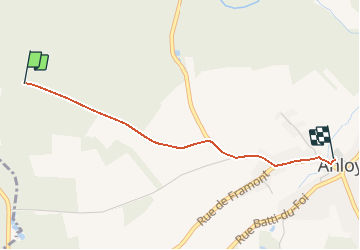
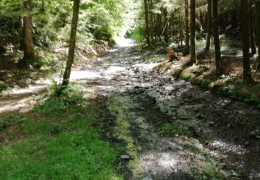
Trail Walking of 2.1 km to be discovered at Wallonia, Luxembourg, Libin. This trail is proposed by La Grande Forêt de Saint-Hubert.
Description
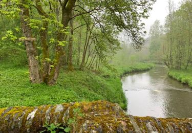
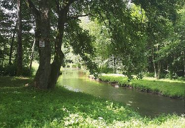
Ce parcours permet de relier le parcours "Entre Lesse et Lomme", du point 30-A "Trois Fontaines", au village d'Anloy..
Positioning
Country:
Belgium
Region :
Wallonia
Department/Province :
Luxembourg
Municipality :
Libin
Location:
Anloy
Start:(Dec)
Start:(UTM)
657411 ; 5535871 (31U) N.
Comments
Trails nearby
![Trail Walking Paliseul - RB-Lu-10_Maissin - Photo](https://media.geolcdn.com/t/375/260/ext.jpg?maxdim=2&url=https%3A%2F%2Fservices.sitytrail.com%2FGeolivesWS%2FDownloadMedia.ashx%3FTrailID%3D315513%26Media%3D52f53adc-4763-4371-9efe-70f027b21c91.jpg)
![Walking Walking](https://static1.geolcdn.com/sitytour/trail-icons/101.png)
RB-Lu-10_Maissin
Walking
Difficult
(7)
Paliseul,
Wallonia,
Luxembourg,
Belgium
![](/images/other/stat-length.png)
25 km | 32 km-effort
6h 38min
![](https://static1.geolcdn.com/siteimages/upload/files/16400158638029165_repeat_loop_refresh_sync_direction_icon.png)
Yes
![Trail Walking Libin - Lesse - Promenade de la Lesse (LI06) - Photo](https://media.geolcdn.com/t/375/260/ext.jpg?maxdim=2&url=https%3A%2F%2Fmedia.geolcdn.com%2Ff%2F27528ace-a0b8-4107-8825-6100f3450bfd.jpg)
![Walking Walking](https://static1.geolcdn.com/sitytour/trail-icons/101.png)
Lesse - Promenade de la Lesse (LI06)
Walking
Medium
(6)
Libin,
Wallonia,
Luxembourg,
Belgium
![](/images/other/stat-length.png)
8.6 km | 11.3 km-effort
2h 26min
![](https://static1.geolcdn.com/siteimages/upload/files/16400158638029165_repeat_loop_refresh_sync_direction_icon.png)
Yes
![Trail Walking Libin - Lesse - Entre Lesse et Lomme - Photo](https://media.geolcdn.com/t/375/260/ext.jpg?maxdim=2&url=https%3A%2F%2Fmedia.geolcdn.com%2Ff%2F29de6fa8-4c44-40a4-a5ee-a6e3f0f650e2.jpg)
![Walking Walking](https://static1.geolcdn.com/sitytour/trail-icons/101.png)
Lesse - Entre Lesse et Lomme
Walking
Very easy
(2)
Libin,
Wallonia,
Luxembourg,
Belgium
![](/images/other/stat-length.png)
78 km | 102 km-effort
20h 32min
![](https://static1.geolcdn.com/siteimages/upload/files/16400158638029165_repeat_loop_refresh_sync_direction_icon.png)
Yes
![Trail Walking Paliseul - RB-LUX-10 - Raccourci 2 - Le long de deux rivières fougueuses : l’Our et la Lesse - Photo](https://media.geolcdn.com/t/375/260/ext.jpg?maxdim=2&url=https%3A%2F%2Fservices.sitytrail.com%2FGeolivesWS%2FDownloadMedia.ashx%3FTrailID%3D216782%26Media%3D52f53adc-4763-4371-9efe-70f027b21c91.jpg)
![Walking Walking](https://static1.geolcdn.com/sitytour/trail-icons/101.png)
RB-LUX-10 - Raccourci 2 - Le long de deux rivières fougueuses : l’Our et la L...
Walking
Easy
(2)
Paliseul,
Wallonia,
Luxembourg,
Belgium
![](/images/other/stat-length.png)
22 km | 29 km-effort
4h 6min
![](https://static1.geolcdn.com/siteimages/upload/files/16400158638029165_repeat_loop_refresh_sync_direction_icon.png)
Yes
![Trail Walking Paliseul - RB-LUX-10 - Raccourci 1 - Le long de deux rivières fougueuses : l’Our et la Lesse - Photo](https://media.geolcdn.com/t/375/260/ext.jpg?maxdim=2&url=https%3A%2F%2Fservices.sitytrail.com%2FGeolivesWS%2FDownloadMedia.ashx%3FTrailID%3D179615%26Media%3D52f53adc-4763-4371-9efe-70f027b21c91.jpg)
![Walking Walking](https://static1.geolcdn.com/sitytour/trail-icons/101.png)
RB-LUX-10 - Raccourci 1 - Le long de deux rivières fougueuses : l’Our et la L...
Walking
Medium
(2)
Paliseul,
Wallonia,
Luxembourg,
Belgium
![](/images/other/stat-length.png)
14.9 km | 19.4 km-effort
5h 59min
![](https://static1.geolcdn.com/siteimages/upload/files/16400158638029165_repeat_loop_refresh_sync_direction_icon.png)
Yes
![Trail Walking Libin - ANLOY (Cimetière Militaire) - Photo](https://media.geolcdn.com/t/375/260/ext.jpg?maxdim=2&url=https%3A%2F%2Fservices.sitytrail.com%2FGeolivesWS%2FDownloadMedia.ashx%3FTrailID%3D1004824%26Media%3Dfix__20180715114717.jpg)
![Walking Walking](https://static1.geolcdn.com/sitytour/trail-icons/101.png)
ANLOY (Cimetière Militaire)
Walking
Easy
Libin,
Wallonia,
Luxembourg,
Belgium
![](/images/other/stat-length.png)
11.1 km | 13.8 km-effort
2h 59min
![](https://static1.geolcdn.com/siteimages/upload/files/16400158638029165_repeat_loop_refresh_sync_direction_icon.png)
Yes
![Trail Walking Libin - Villance - Promenade des Ponts (LI14) - Photo](https://media.geolcdn.com/t/375/260/ext.jpg?maxdim=2&url=https%3A%2F%2Fmedia.geolcdn.com%2Ff%2Ffe9fccf1-9bca-4e04-ac67-5acf6a5bba21.jpg)
![Walking Walking](https://static1.geolcdn.com/sitytour/trail-icons/101.png)
Villance - Promenade des Ponts (LI14)
Walking
Easy
(4)
Libin,
Wallonia,
Luxembourg,
Belgium
![](/images/other/stat-length.png)
8.1 km | 9.7 km-effort
2h 8min
![](https://static1.geolcdn.com/siteimages/upload/files/16400158638029165_repeat_loop_refresh_sync_direction_icon.png)
Yes
![Trail Walking Libin - Lesse - Virée à Chène (LI08) - Photo](https://media.geolcdn.com/t/375/260/ext.jpg?maxdim=2&url=https%3A%2F%2Fmedia.geolcdn.com%2Ff%2F90bf87f0-b495-4e76-bcdc-cb0533bbc55d.jpg)
![Walking Walking](https://static1.geolcdn.com/sitytour/trail-icons/101.png)
Lesse - Virée à Chène (LI08)
Walking
Easy
(5)
Libin,
Wallonia,
Luxembourg,
Belgium
![](/images/other/stat-length.png)
5.7 km | 7.7 km-effort
1h 43min
![](https://static1.geolcdn.com/siteimages/upload/files/16400158638029165_repeat_loop_refresh_sync_direction_icon.png)
Yes
![Trail Mountain bike Paliseul - maissin our lesse 24km - Photo](https://media.geolcdn.com/t/375/260/ext.jpg?maxdim=2&url=https%3A%2F%2Fmedia.geolcdn.com%2Ff%2F45d0ded6-8867-40dc-bc8a-0d2bab7c3e61.jpg)
![Mountain bike Mountain bike](https://static1.geolcdn.com/sitytour/trail-icons/202.png)
maissin our lesse 24km
Mountain bike
Medium
(1)
Paliseul,
Wallonia,
Luxembourg,
Belgium
![](/images/other/stat-length.png)
20 km | 26 km-effort
1h 46min
![](https://static1.geolcdn.com/siteimages/upload/files/16400158638029165_repeat_loop_refresh_sync_direction_icon.png)
Yes