


allauch la montade

ARPF
User
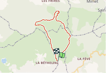

Length
14.9 km

Max alt
669 m

Uphill gradient
633 m
Km-Effort
23 km

Min alt
189 m

Downhill gradient
543 m
Boucle
No
Creation date :
2017-03-26 00:00:00.0
Updated on :
2017-03-26 00:00:00.0
6h35
Difficulty : Medium

FREE GPS app for hiking
 SityTrail
IGN / Geographical institutes
SityTrail Plus
The world is yours!
About
Trail Walking of 14.9 km to be discovered at Provence-Alpes-Côte d'Azur, Bouches-du-Rhône, Plan-de-Cuques. This trail is proposed by ARPF.
Positioning
Country:
France
Region :
Provence-Alpes-Côte d'Azur
Department/Province :
Bouches-du-Rhône
Municipality :
Plan-de-Cuques
Location:
Unknown
Start:(Dec)
Start:(UTM)
699644 ; 4803972 (31T) N.
Comments