bel air

jeanfcd
User
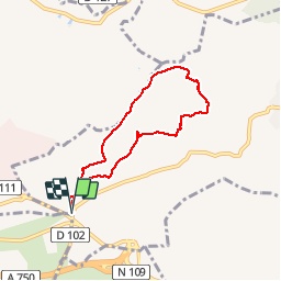

Length
6.4 km

Max alt
155 m

Uphill gradient
90 m
Km-Effort
7.6 km

Min alt
89 m

Downhill gradient
90 m
Boucle
Yes
Creation date :
2017-03-26 00:00:00.0
Updated on :
2017-03-26 00:00:00.0
1h54
Difficulty : Very easy

FREE GPS app for hiking
 SityTrail
IGN / Geographical institutes
SityTrail Plus
The world is yours!
About
Trail Walking of 6.4 km to be discovered at Occitania, Hérault, Grabels. This trail is proposed by jeanfcd.
Positioning
Country:
France
Region :
Occitania
Department/Province :
Hérault
Municipality :
Grabels
Location:
Unknown
Start:(Dec)
Start:(UTM)
560459 ; 4832128 (31T) N.
Comments