


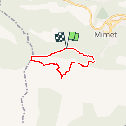
Col Ste Anne Piste

ARPF
User

Length
5.1 km

Max alt
718 m

Uphill gradient
266 m
Km-Effort
8.7 km

Min alt
535 m

Downhill gradient
263 m
Boucle
Yes
Creation date :
2017-03-28 00:00:00.0
Updated on :
2017-03-28 00:00:00.0
10m
Difficulty : Medium

FREE GPS app for hiking
 SityTrail
IGN / Geographical institutes
SityTrail Plus
The world is yours!
About
Trail Walking of 5.1 km to be discovered at Provence-Alpes-Côte d'Azur, Bouches-du-Rhône, Mimet. This trail is proposed by ARPF.
Description
Reco à faire pour 1/2 journée.
P1 T1
Positioning
Country:
France
Region :
Provence-Alpes-Côte d'Azur
Department/Province :
Bouches-du-Rhône
Municipality :
Mimet
Location:
Unknown
Start:(Dec)
Start:(UTM)
701680 ; 4809438 (31T) N.
Comments