


Col Croix Perrin 2017

ARPF
User
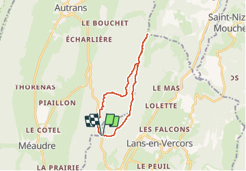

Length
11.8 km

Max alt
1667 m

Uphill gradient
477 m
Km-Effort
18.2 km

Min alt
1200 m

Downhill gradient
485 m
Boucle
Yes
Creation date :
2018-01-12 00:00:00.0
Updated on :
2018-01-12 00:00:00.0
6h33
Difficulty : Medium

FREE GPS app for hiking
 SityTrail
IGN / Geographical institutes
SityTrail Plus
The world is yours!
About
Trail Snowshoes of 11.8 km to be discovered at Auvergne-Rhône-Alpes, Isère, Lans-en-Vercors. This trail is proposed by ARPF.
Description
P2 T1
rando sur la crête avec une vue magnifique sur la vallée.
Peut être raccourcie.
PhG
Positioning
Country:
France
Region :
Auvergne-Rhône-Alpes
Department/Province :
Isère
Municipality :
Lans-en-Vercors
Location:
Unknown
Start:(Dec)
Start:(UTM)
701329 ; 5000632 (31T) N.
Comments