


Lacs Robert depuis la cascade de l''Oursi?re

McTracy004
User
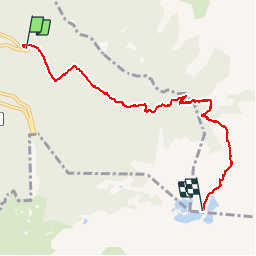

Length
6.6 km

Max alt
2016 m

Uphill gradient
900 m
Km-Effort
15.8 km

Min alt
1126 m

Downhill gradient
38 m
Boucle
No
Creation date :
2014-12-10 00:00:00.0
Updated on :
2014-12-10 00:00:00.0
3h44
Difficulty : Medium

FREE GPS app for hiking
 SityTrail
IGN / Geographical institutes
SityTrail Plus
The world is yours!
About
Trail Walking of 6.6 km to be discovered at Auvergne-Rhône-Alpes, Isère, Saint-Martin-d'Uriage. This trail is proposed by McTracy004.
Positioning
Country:
France
Region :
Auvergne-Rhône-Alpes
Department/Province :
Isère
Municipality :
Saint-Martin-d'Uriage
Location:
Unknown
Start:(Dec)
Start:(UTM)
726919 ; 5003850 (31T) N.
Comments