


balade en halatte 30 mars 17

gilbertdu60
User
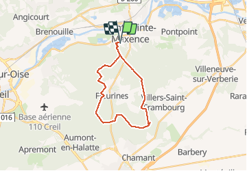

Length
21 km

Max alt
149 m

Uphill gradient
242 m
Km-Effort
24 km

Min alt
87 m

Downhill gradient
242 m
Boucle
Yes
Creation date :
2017-03-30 00:00:00.0
Updated on :
2017-03-30 00:00:00.0
1h43
Difficulty : Medium

FREE GPS app for hiking
 SityTrail
IGN / Geographical institutes
SityTrail Plus
The world is yours!
About
Trail Cycle of 21 km to be discovered at Hauts-de-France, Oise, Pont-Sainte-Maxence. This trail is proposed by gilbertdu60.
Description
balade halatte nord est ouest
Positioning
Country:
France
Region :
Hauts-de-France
Department/Province :
Oise
Municipality :
Pont-Sainte-Maxence
Location:
Unknown
Start:(Dec)
Start:(UTM)
470584 ; 5460256 (31U) N.
Comments