


Calvisson les garrigues gardoises

grageot
User
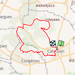

Length
17.3 km

Max alt
207 m

Uphill gradient
358 m
Km-Effort
22 km

Min alt
55 m

Downhill gradient
357 m
Boucle
Yes
Creation date :
2017-03-31 00:00:00.0
Updated on :
2017-03-31 00:00:00.0
4h50
Difficulty : Easy

FREE GPS app for hiking
 SityTrail
IGN / Geographical institutes
SityTrail Plus
The world is yours!
About
Trail Walking of 17.3 km to be discovered at Occitania, Gard, Calvisson. This trail is proposed by grageot.
Description
Une ballade dans les garrigues sans difficulté mais bien suivre le topo il y a des départs de chemins partout.
De beaux panoramas sur la plaine gardoise et les Cévennes
Positioning
Country:
France
Region :
Occitania
Department/Province :
Gard
Municipality :
Calvisson
Location:
Unknown
Start:(Dec)
Start:(UTM)
595838 ; 4848851 (31T) N.
Comments