


29.03.2017 - FORÊT MONTAUBAN Corrigé

babeth35
User

Length
30 km

Max alt
124 m

Uphill gradient
284 m
Km-Effort
33 km

Min alt
54 m

Downhill gradient
283 m
Boucle
Yes
Creation date :
2017-04-02 00:00:00.0
Updated on :
2020-07-20 15:19:04.415
7h13
Difficulty : Medium

FREE GPS app for hiking
 SityTrail
IGN / Geographical institutes
SityTrail Plus
The world is yours!
About
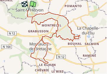
Trail Walking of 30 km to be discovered at Brittany, Ille-et-Vilaine, Montauban-de-Bretagne. This trail is proposed by babeth35.
Positioning
Country:
France
Region :
Brittany
Department/Province :
Ille-et-Vilaine
Municipality :
Montauban-de-Bretagne
Location:
Unknown
Start:(Dec)
Start:(UTM)
569872 ; 5342040 (30U) N.
Comments