


roseraie

topolino
User
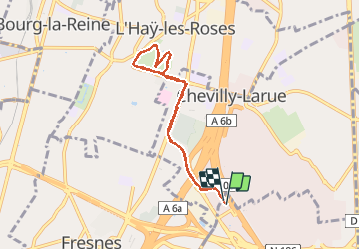

Length
7.8 km

Max alt
97 m

Uphill gradient
83 m
Km-Effort
8.9 km

Min alt
72 m

Downhill gradient
81 m
Boucle
Yes
Creation date :
2017-04-02 00:00:00.0
Updated on :
2017-04-02 00:00:00.0
51m
Difficulty : Very easy

FREE GPS app for hiking
 SityTrail
IGN / Geographical institutes
SityTrail Plus
The world is yours!
About
Trail Running of 7.8 km to be discovered at Ile-de-France, Val-de-Marne, Rungis. This trail is proposed by topolino.
Positioning
Country:
France
Region :
Ile-de-France
Department/Province :
Val-de-Marne
Municipality :
Rungis
Location:
Unknown
Start:(Dec)
Start:(UTM)
451941 ; 5400874 (31U) N.
Comments