


Villars - Les ocres de la Bruyere

mhetpierre
User
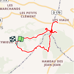

Length
8.6 km

Max alt
406 m

Uphill gradient
220 m
Km-Effort
11.5 km

Min alt
314 m

Downhill gradient
225 m
Boucle
Yes
Creation date :
2018-08-18 15:29:53.099
Updated on :
2018-08-18 15:29:53.099
2h28
Difficulty : Easy

FREE GPS app for hiking
 SityTrail
IGN / Geographical institutes
SityTrail Plus
The world is yours!
About
Trail Walking of 8.6 km to be discovered at Provence-Alpes-Côte d'Azur, Vaucluse, Villars. This trail is proposed by mhetpierre.
Positioning
Country:
France
Region :
Provence-Alpes-Côte d'Azur
Department/Province :
Vaucluse
Municipality :
Villars
Location:
Unknown
Start:(Dec)
Start:(UTM)
694081 ; 4865372 (31T) N.
Comments
Très beau parcours loin de la foule.