Trail On foot Chastreix - Chastreix+la réserve_Bois_dela_Masse - Photo

Chastreix+la réserve_Bois_dela_Masse

 v.rabot
v.rabot

User

© OpenStreetMap contributors
Length
Length
9 km
Max alt
Max alt
1214 m
Uphill gradient
Uphill gradient
250 m
Km-Effort
Km-Effort  
12.4 km
Min alt
Min alt
1023 m
Downhill gradient
Downhill gradient
248 m
Boucle
Boucle
Yes
Creation date :
2017-04-04 00:00:00.0
Updated on :
2023-04-29 19:34:45.179

(1 Reviews)

On foot
On foot
2h48
Difficulty : Easy

Scan this QR Code to open this trail in the SityTrail application

FREE GPS app for hiking

Logo SityTrail SityTrail

IGN / Geographical institutes

Download SityTrail from the App Store Download SityTrail from Google Play

Logo SityTrail SityTrail World

The world is yours!

Download SityTrail from the App Store Download SityTrail from Google Play Download SityTrail on Huawei AppGallery

About

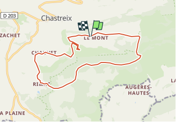
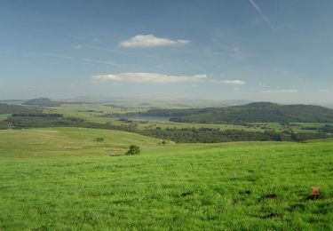
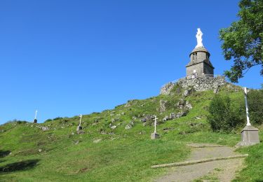
Trail On foot of 9 km to be discovered at Auvergne-Rhône-Alpes, Puy-de-Dôme, Chastreix. This trail is proposed by v.rabot.

Description

La cascade est jolie, la zone humide ne l'était pas, pas de difficulté particulière à ce circuit.

Elevation profile

Positioning

Country:
France
Region :
Auvergne-Rhône-Alpes
Department/Province :
Puy-de-Dôme
Municipality :
Chastreix
Location:
Unknown
Start:(UTM)
480187 ; 5039384 (31T) N.

Comments

Please log in to post a review or rate the element


Trails nearby

Trail Walking Chastreix - Chastreix. cascades et tourbières  - Photo
Walking
olivier78000

Walking

Easy
(1)
Chastreix, Auvergne-Rhône-Alpes, Puy-de-Dôme, France
13.8 km | 18.3 km-effort
4h 5min
Yes
Trail Mountain bike Picherande - Espace VTT FFC du Sancy - Circuit n°10 - L'Escudor - Secteur Picherande  - Photo
Mountain bike
tracegps

Mountain bike

Difficult
(1)
Picherande, Auvergne-Rhône-Alpes, Puy-de-Dôme, France
14.9 km | 19.8 km-effort
1h 10min
Yes
Trail On foot La Tour-d'Auvergne - Chambourguet - Photo
On foot
PRO

On foot

Medium
La Tour-d'Auvergne, Auvergne-Rhône-Alpes, Puy-de-Dôme, France
16.8 km | 23 km-effort
5h 17min
Yes
Trail On foot Saint-Donat - Bertinet - Photo
On foot
PRO

On foot

Easy
Saint-Donat, Auvergne-Rhône-Alpes, Puy-de-Dôme, France
7.9 km | 10 km-effort
2h 15min
Yes
Trail On foot Chastreix - Bois de la Masse - Photo
On foot
PRO

On foot

Easy
Chastreix, Auvergne-Rhône-Alpes, Puy-de-Dôme, France
12.2 km | 16.2 km-effort
3h 40min
Yes
Trail On foot La Tour-d'Auvergne - Notre Dame de Natzy - Photo
On foot
PRO

On foot

Easy
La Tour-d'Auvergne, Auvergne-Rhône-Alpes, Puy-de-Dôme, France
4.1 km | 5.8 km-effort
1h 19min
No
Trail On foot Picherande - La Fontaine Salée - Photo
On foot
PRO

On foot

Medium
Picherande, Auvergne-Rhône-Alpes, Puy-de-Dôme, France
20 km | 29 km-effort
6h 41min
Yes
Trail On foot Mont-Dore - Le Capucin et le Puy de Cliergue - Photo
On foot
PRO

On foot

Easy
Mont-Dore, Auvergne-Rhône-Alpes, Puy-de-Dôme, France
10.8 km | 18.4 km-effort
4h 10min
Yes
Trail On foot Mont-Dore - Le Puy de Sancy - Photo
On foot
PRO

On foot

Easy
Mont-Dore, Auvergne-Rhône-Alpes, Puy-de-Dôme, France
6.9 km | 14 km-effort
3h 10min
Yes


Close
My subscriptions