


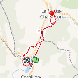
Boucle Pas des Ondes - la Motte Chalancon

BernardSalomon
User

Length
9.8 km

Max alt
613 m

Uphill gradient
171 m
Km-Effort
12.1 km

Min alt
515 m

Downhill gradient
173 m
Boucle
Yes
Creation date :
2017-04-04 00:00:00.0
Updated on :
2017-04-04 00:00:00.0
2h42
Difficulty : Easy

FREE GPS app for hiking
 SityTrail
IGN / Geographical institutes
SityTrail Plus
The world is yours!
About
Trail Walking of 9.8 km to be discovered at Auvergne-Rhône-Alpes, Drôme, Cornillon-sur-l'Oule. This trail is proposed by BernardSalomon.
Positioning
Country:
France
Region :
Auvergne-Rhône-Alpes
Department/Province :
Drôme
Municipality :
Cornillon-sur-l'Oule
Location:
Unknown
Start:(Dec)
Start:(UTM)
688386 ; 4926129 (31T) N.
Comments