Trail Walking Broc - Gorges de la Jogne, lac de Montsalvens circuit 07.04.17 - Photo

Gorges de la Jogne, lac de Montsalvens circuit 07.04.17

 duamerg
duamerg

User

© OpenStreetMap contributors
Length
Length
12.6 km
Max alt
Max alt
984 m
Uphill gradient
Uphill gradient
477 m
Km-Effort
Km-Effort  
19 km
Min alt
Min alt
716 m
Downhill gradient
Downhill gradient
476 m
Boucle
Boucle
Yes
Creation date :
2017-04-08 00:00:00.0
Updated on :
2020-01-30 13:55:46.431

(0 Reviews)

Walking
Walking
4h17
Difficulty : Medium

Scan this QR Code to open this trail in the SityTrail application

FREE GPS app for hiking

Logo SityTrail SityTrail

IGN / Geographical institutes

Download SityTrail from the App Store Download SityTrail from Google Play

Logo SityTrail SityTrail World

The world is yours!

Download SityTrail from the App Store Download SityTrail from Google Play Download SityTrail on Huawei AppGallery

About

Trail Walking of 12.6 km to be discovered at Fribourg, Gruyère District, Broc. This trail is proposed by duamerg.

Description

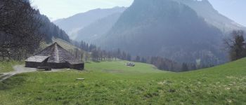
A la sortie de Broc prendre à droite juste avant le pont sur la Jogne et laisser la voiture.
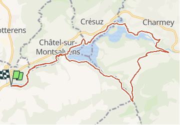
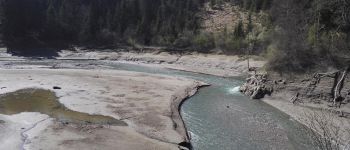
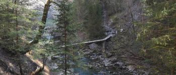
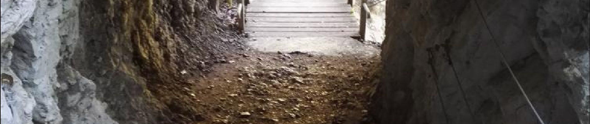
Très belle gorge qui par tunnels, ponts et beaucoup d'escaliers va vous mener au plus ancien barrage en arc de suisse (1921 sauf erreur).
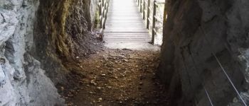
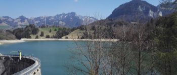
Prendre la direction de Charmey. Un joli chemin longe ce lac tortueux.
Un vrai pont suspendu vous permet de changer de rive et d'atteindre Charmey (2h15 pour faire cette partie, bus pour le retour).
Pas d'arrêt dans ce village car nous bifurquons avant et suivons maintenant les indicateurs 'tour du lac'.
Après avoir traversé la Jogne, suivre la conduite forcée jusqu'à la route. Peu de temps après vous allez la quitter pour une bonne grimpée en forêt pour atteindre le lieu dit La Monse avec sa petite chapelle.
Redescendons tout ce que l'on a monté pour rejoindre le cours du ruisseau de Motélon.
Nous le suivons jusqu'à retrouver le lac et le barrage. Retour par les gorges.
Très jolie course variée sur de bons chemins pour une fois pratiquement sans goudron.
Pas de difficultés particulières. Les gorges vous font oublier la fatigue :-)

Elevation profile

Photos

Points of interest

Point of interest Châtel-sur-Montsalvens - le barrage - Photo
duamerg
CHÂTEL-SUR-MONTSALVENS 
Point of interest Broc - place de pic nic - Photo
duamerg
Point of interest Val-de-Charmey - place de picnic - Photo
duamerg
VAL-DE-CHARMEY 
Point of interest Val-de-Charmey - passerelle suspendue - Photo
duamerg
VAL-DE-CHARMEY 
Point of interest Val-de-Charmey - point de vue  - Photo
duamerg
VAL-DE-CHARMEY 
Point of interest Val-de-Charmey - bus, restaurants, magasins - Photo
duamerg
Point of interest Val-de-Charmey - bel endroit - Photo
duamerg
VAL-DE-CHARMEY 
Point of interest Val-de-Charmey - picnic  - Photo
duamerg
VAL-DE-CHARMEY 
Point of interest Châtel-sur-Montsalvens - dernier pont - Photo
duamerg
CHÂTEL-SUR-MONTSALVENS 

Positioning

Country:
Switzerland
Region :
Fribourg
Department/Province :
Gruyère District
Municipality :
Broc
Location:
Unknown
Start:(UTM)
355500 ; 5162959 (32T) N.

Trails nearby

Trail Walking Bulle - Broc FR - Notre Dame des Marches - Photo
Walking
furggstalden

Walking

Very easy
(1)
Bulle, Fribourg, Gruyère District, Switzerland
14.3 km | 19.7 km-effort
4h 37min
Yes
Trail Nordic walking Val-de-Charmey - Treek charmey au lac noir.  - Photo
Nordic walking
paspas28

Nordic walking

Easy
Val-de-Charmey, Fribourg, Gruyère District, Switzerland
21 km | 33 km-effort
5h 4min
Yes
Trail On foot Bas-Intyamon - Motélon-La Gueyre - Photo
On foot
PRO

On foot

Easy
Bas-Intyamon, Fribourg, Gruyère District, Switzerland
6.4 km | 14.3 km-effort
3h 14min
No
Trail Other activity Bas-Intyamon - y10_poyas - Photo
Other activity
GUIDE+

Other activity

Very easy
Bas-Intyamon, Fribourg, Gruyère District, Switzerland
16.1 km | 25 km-effort
5h 43min
No
Trail Cycle Gruyères - st_ral_5 - Photo
Cycle
GUIDE+

Cycle

Very easy
Gruyères, Fribourg, Gruyère District, Switzerland
34 km | 55 km-effort
Unknown
No
Trail Mountain bike Val-de-Charmey - La Berra - Photo
Mountain bike
GUIDE+

Mountain bike

Very easy
Val-de-Charmey, Fribourg, Gruyère District, Switzerland
30 km | 44 km-effort
10h 0min
Yes
Trail Walking Val-de-Charmey - Charmey: Tolle Rundsichten von Vounetse - Photo
Walking
GUIDE+

Walking

Very easy
Val-de-Charmey, Fribourg, Gruyère District, Switzerland
7.4 km | 17 km-effort
Unknown
No
Trail Mountain bike Val-de-Charmey - Bike32902 - Photo
Mountain bike
GUIDE+

Mountain bike

Very easy
Val-de-Charmey, Fribourg, Gruyère District, Switzerland
21 km | 31 km-effort
Unknown
Yes
Trail Other activity Val-de-Charmey - w10_04_gruyere - Photo
Other activity
GUIDE+

Other activity

Very easy
Val-de-Charmey, Fribourg, Gruyère District, Switzerland
10.8 km | 14.8 km-effort
3h 53min
No


Close
My subscriptions