


plateau Amber et roc de Toulaud

ajd26
User
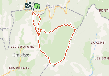

Length
17.8 km

Max alt
1529 m

Uphill gradient
777 m
Km-Effort
28 km

Min alt
1197 m

Downhill gradient
772 m
Boucle
Yes
Creation date :
2019-05-19 18:03:45.454
Updated on :
2020-01-06 17:32:04.741
4h49
Difficulty : Difficult

FREE GPS app for hiking
 SityTrail
IGN / Geographical institutes
SityTrail Plus
The world is yours!
About
Trail Walking of 17.8 km to be discovered at Auvergne-Rhône-Alpes, Drôme, Omblèze. This trail is proposed by ajd26.
Description
Départ col de la Bataille après le tunnel
Positioning
Country:
France
Region :
Auvergne-Rhône-Alpes
Department/Province :
Drôme
Municipality :
Omblèze
Location:
Unknown
Start:(Dec)
Start:(UTM)
676387 ; 4973945 (31T) N.
Comments