


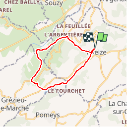
69 AVEIZE Autour du Chatelard

trietsch
User

Length
10.8 km

Max alt
787 m

Uphill gradient
393 m
Km-Effort
16 km

Min alt
454 m

Downhill gradient
393 m
Boucle
Yes
Creation date :
2017-04-10 00:00:00.0
Updated on :
2020-01-04 20:29:11.955
3h21
Difficulty : Medium

FREE GPS app for hiking
 SityTrail
IGN / Geographical institutes
SityTrail Plus
The world is yours!
About
Trail Walking of 10.8 km to be discovered at Auvergne-Rhône-Alpes, Rhône, Aveize. This trail is proposed by trietsch.
Description
sens inverse balisage jaune
Positioning
Country:
France
Region :
Auvergne-Rhône-Alpes
Department/Province :
Rhône
Municipality :
Aveize
Location:
Unknown
Start:(Dec)
Start:(UTM)
615026 ; 5059891 (31T) N.
Comments