


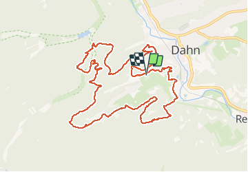
Dahner Felsenpfad

VacheKiri67
User


6h05
Difficulty : Medium

FREE GPS app for hiking
 SityTrail
IGN / Geographical institutes
SityTrail Plus
The world is yours!
About
Trail Walking of 13.5 km to be discovered at Rhineland-Palatinate, Südwestpfalz, Dahn. This trail is proposed by VacheKiri67.
Description
Faite le 09/04/2017 avec notre fils Théo de 12 ans et nos amis Eléonore, Jennifer, Bernard et Rémy. Durée indiquée pour le circuit : 5h. Plusieurs randonnées sont disponibles ici http://www.dahner-felsenland.net/vg_dahner_felsenland/Aktuelles/Wanderkarte Premiumwege/Wanderkarte_Premiumwege_0316_web_neu.pdf
Photos


41 photos in total. Please click on a photo to see them all in the gallery.
Positioning
Comments
Cette superbe randonnée vous fera découvrir une succession de 15 rochers remarquables !