


Dans la région d'Aywaille

mozzipsc
User
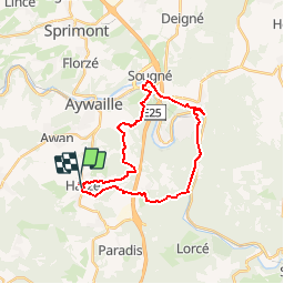

Length
23 km

Max alt
387 m

Uphill gradient
654 m
Km-Effort
31 km

Min alt
128 m

Downhill gradient
643 m
Boucle
No
Creation date :
2017-04-14 00:00:00.0
Updated on :
2017-04-14 00:00:00.0
6h50
Difficulty : Medium

FREE GPS app for hiking
 SityTrail
IGN / Geographical institutes
SityTrail Plus
The world is yours!
About
Trail Walking of 23 km to be discovered at Wallonia, Liège, Aywaille. This trail is proposed by mozzipsc.
Description
Boucle en GR 575 571 où bois, forêt, campagne, cours d'eau, sentiers en tout genre, nous font découvrir cette belle région du Condroz.
Positioning
Country:
Belgium
Region :
Wallonia
Department/Province :
Liège
Municipality :
Aywaille
Location:
Harzé
Start:(Dec)
Start:(UTM)
689219 ; 5591151 (31U) N.
Comments