![](/images/other/stat-length.png)
![Trail Cycle Uxem - J3_nord_velo2017 - Photo](https://media.geolcdn.com/t/1900/400/ext.pjpeg?maxdim=2&url=https%3A%2F%2Fstatic1.geolcdn.com%2Fsiteimages%2Fupload%2Ffiles%2F1524743154velo.jpg)
J3_nord_velo2017
FABLUK
User
![Length](/images/other/stat-length.png)
Length
73 km
![Max alt](https://static1.geolcdn.com/siteimages/upload/files/1508320355ic_sort_altitude_max_24dp.png)
Max alt
57 m
![Uphill gradient](https://static1.geolcdn.com/siteimages/upload/files/1508320355ic_sort_den_pos_24dp.png)
Uphill gradient
352 m
![Km-Effort](/images/other/stat-length.png)
Km-Effort
78 km
![Min alt](https://static1.geolcdn.com/siteimages/upload/files/1508320355ic_sort_altitude_min_24dp.png)
Min alt
-5 m
![Downhill gradient](https://static1.geolcdn.com/siteimages/upload/files/1508320355ic_sort_den_neg_24dp.png)
Downhill gradient
325 m
![Boucle](https://static1.geolcdn.com/siteimages/upload/files/16400158638029165_repeat_loop_refresh_sync_direction_icon.png)
Boucle
No
Creation date :
2017-04-14 00:00:00.0
Updated on :
2017-04-14 00:00:00.0
![Cycle](https://static1.geolcdn.com/sitytour/trail-icons/200.png)
4h29
Difficulty : Very difficult
![Scan this QR Code to open this trail in the SityTrail application](https://capi.geolives.com/qq0zvz2zws4bq2lad0pu/sitytour/trails/732373/qr.png?size=200)
FREE GPS app for hiking
About
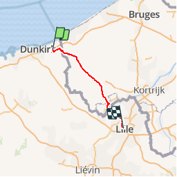
Trail Cycle of 73 km to be discovered at Hauts-de-France, Nord, Uxem. This trail is proposed by FABLUK.
Description
départ: Auberge de la Ferme Hooghe Moote 188 Route d'Uxem, 59254 Ghyvelde
arrivée: Hotel https://www.hotelkanai.com/ Téléphone: 0320571478
L’entrée se situe rue de la Vieille Comédie au dessus du magasin CAROLL
Adresse: 10 Rue de Béthune, 59800 Lille, France
Positioning
Country:
France
Region :
Hauts-de-France
Department/Province :
Nord
Municipality :
Uxem
Location:
Unknown
Start:(Dec)
Start:(UTM)
464800 ; 5653417 (31U) N.
Comments
Trails nearby
![Trail Walking Ghyvelde - Circuit de la dune fossile - Photo](https://media.geolcdn.com/t/375/260/ext.jpg?maxdim=2&url=https%3A%2F%2Fservices.sitytrail.com%2FGeolivesWS%2FDownloadMedia.ashx%3FTrailID%3D202884%26Media%3De70f8078-3884-40d7-916d-9c1e8d1873d8.jpg)
![Walking Walking](https://static1.geolcdn.com/sitytour/trail-icons/101.png)
Circuit de la dune fossile
Walking
Very easy
(3)
Ghyvelde,
Hauts-de-France,
Nord,
France
![](/images/other/stat-length.png)
7.8 km | 8.4 km-effort
Unknown
![](https://static1.geolcdn.com/siteimages/upload/files/16400158638029165_repeat_loop_refresh_sync_direction_icon.png)
Yes
![Trail Walking Zuydcoote - Circuit de l'Hôpital maritime - Zuydcoote - Photo](https://media.geolcdn.com/t/375/260/ext.jpg?maxdim=2&url=https%3A%2F%2Fservices.sitytrail.com%2FGeolivesWS%2FDownloadMedia.ashx%3FTrailID%3D109094%26Media%3D3144_6.jpg)
![Walking Walking](https://static1.geolcdn.com/sitytour/trail-icons/101.png)
Circuit de l'Hôpital maritime - Zuydcoote
Walking
Easy
(1)
Zuydcoote,
Hauts-de-France,
Nord,
France
![](/images/other/stat-length.png)
4.5 km | 4.9 km-effort
1h 15min
![](https://static1.geolcdn.com/siteimages/upload/files/16400158638029165_repeat_loop_refresh_sync_direction_icon.png)
Yes
![Trail Walking Bray-Dunes - dune Marchand - Photo](https://media.geolcdn.com/t/375/260/ext.jpg?maxdim=2&url=https%3A%2F%2Fstatic1.geolcdn.com%2Fsiteimages%2Fupload%2Ffiles%2F1553511878bg_sport_marche.png)
![Walking Walking](https://static1.geolcdn.com/sitytour/trail-icons/101.png)
dune Marchand
Walking
Medium
(1)
Bray-Dunes,
Hauts-de-France,
Nord,
France
![](/images/other/stat-length.png)
9.1 km | 9.8 km-effort
2h 30min
![](https://static1.geolcdn.com/siteimages/upload/files/16400158638029165_repeat_loop_refresh_sync_direction_icon.png)
Yes
![Trail On foot Zuydcoote - Circuit de la dune Marchand - Zuydcoote - Photo](https://media.geolcdn.com/t/375/260/ext.jpg?maxdim=2&url=https%3A%2F%2Fmedia.geolcdn.com%2Ff%2F80639f4b-4b2c-4c13-bf37-87df4eff0893.jpeg)
![On foot On foot](https://static1.geolcdn.com/sitytour/trail-icons/100.png)
Circuit de la dune Marchand - Zuydcoote
On foot
Easy
Zuydcoote,
Hauts-de-France,
Nord,
France
![](/images/other/stat-length.png)
3.9 km | 4.2 km-effort
56min
![](https://static1.geolcdn.com/siteimages/upload/files/16400158638029165_repeat_loop_refresh_sync_direction_icon.png)
No
![Trail Walking Zuydcoote - Circuit de la dune marchand - Photo](https://media.geolcdn.com/t/375/260/ext.jpg?maxdim=2&url=https%3A%2F%2Fservices.sitytrail.com%2FGeolivesWS%2FDownloadMedia.ashx%3FTrailID%3D202885%26Media%3D6557392e-0d70-4854-8070-e11053f0b96d.jpg)
![Walking Walking](https://static1.geolcdn.com/sitytour/trail-icons/101.png)
Circuit de la dune marchand
Walking
Very easy
Zuydcoote,
Hauts-de-France,
Nord,
France
![](/images/other/stat-length.png)
9.2 km | 10 km-effort
Unknown
![](https://static1.geolcdn.com/siteimages/upload/files/16400158638029165_repeat_loop_refresh_sync_direction_icon.png)
Yes
![Trail Mountain bike Uxem - Bois des Forts et Canal de Bergues à Coudekerque - Uxem - Photo](https://media.geolcdn.com/t/375/260/ext.jpg?maxdim=2&url=https%3A%2F%2Fservices.sitytrail.com%2FGeolivesWS%2FDownloadMedia.ashx%3FTrailID%3D129696%26Media%3D13233_3.jpg)
![Mountain bike Mountain bike](https://static1.geolcdn.com/sitytour/trail-icons/202.png)
Bois des Forts et Canal de Bergues à Coudekerque - Uxem
Mountain bike
Medium
(1)
Uxem,
Hauts-de-France,
Nord,
France
![](/images/other/stat-length.png)
31 km | 33 km-effort
1h 30min
![](https://static1.geolcdn.com/siteimages/upload/files/16400158638029165_repeat_loop_refresh_sync_direction_icon.png)
Yes
![Trail Cycle Ghyvelde - Circuit des Polders - Ghyvelde - Photo](https://media.geolcdn.com/t/375/260/ext.jpg?maxdim=2&url=https%3A%2F%2Fservices.sitytrail.com%2FGeolivesWS%2FDownloadMedia.ashx%3FTrailID%3D111981%26Media%3D9287_6.jpg)
![Cycle Cycle](https://static1.geolcdn.com/sitytour/trail-icons/200.png)
Circuit des Polders - Ghyvelde
Cycle
Medium
(1)
Ghyvelde,
Hauts-de-France,
Nord,
France
![](/images/other/stat-length.png)
37 km | 39 km-effort
2h 0min
![](https://static1.geolcdn.com/siteimages/upload/files/16400158638029165_repeat_loop_refresh_sync_direction_icon.png)
Yes
![Trail Walking Ghyvelde - Circuit du ringsloot et des watergangs - Photo](https://media.geolcdn.com/t/375/260/ext.jpg?maxdim=2&url=https%3A%2F%2Fservices.sitytrail.com%2FGeolivesWS%2FDownloadMedia.ashx%3FTrailID%3D109478%26Media%3D4029_3.jpg)
![Walking Walking](https://static1.geolcdn.com/sitytour/trail-icons/101.png)
Circuit du ringsloot et des watergangs
Walking
Medium
(1)
Ghyvelde,
Hauts-de-France,
Nord,
France
![](/images/other/stat-length.png)
9.4 km | 9.8 km-effort
2h 19min
![](https://static1.geolcdn.com/siteimages/upload/files/16400158638029165_repeat_loop_refresh_sync_direction_icon.png)
Yes
![Trail Walking Ghyvelde - Circuit de la dune fossile (Ghyvelde) - Photo](https://media.geolcdn.com/t/375/260/ext.jpg?maxdim=2&url=https%3A%2F%2Fservices.sitytrail.com%2FGeolivesWS%2FDownloadMedia.ashx%3FTrailID%3D109469%26Media%3D4012_6.jpg)
![Walking Walking](https://static1.geolcdn.com/sitytour/trail-icons/101.png)
Circuit de la dune fossile (Ghyvelde)
Walking
Easy
(1)
Ghyvelde,
Hauts-de-France,
Nord,
France
![](/images/other/stat-length.png)
7.8 km | 8.4 km-effort
2h 0min
![](https://static1.geolcdn.com/siteimages/upload/files/16400158638029165_repeat_loop_refresh_sync_direction_icon.png)
Yes