


compostelle 2017 mt

MAITHE
User

Length
214 km

Max alt
553 m

Uphill gradient
5977 m
Km-Effort
295 km

Min alt
77 m

Downhill gradient
6208 m
Boucle
No
Creation date :
2017-04-16 00:00:00.0
Updated on :
2017-04-16 00:00:00.0
1666h40
Difficulty : Unknown

FREE GPS app for hiking
 SityTrail
IGN / Geographical institutes
SityTrail Plus
The world is yours!
About
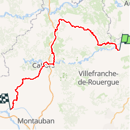
Trail Other activity of 214 km to be discovered at Occitania, Aveyron, Decazeville. This trail is proposed by MAITHE.
Positioning
Country:
France
Region :
Occitania
Department/Province :
Aveyron
Municipality :
Decazeville
Location:
Unknown
Start:(Dec)
Start:(UTM)
441280 ; 4934843 (31T) N.
Comments
c'est pour bientôt
mt
après modif
septembre 2017