


Boucle au golf de bassin bleu

Fdum
User
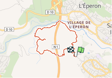

Length
5.6 km

Max alt
304 m

Uphill gradient
167 m
Km-Effort
7.9 km

Min alt
148 m

Downhill gradient
172 m
Boucle
Yes
Creation date :
2017-04-17 00:00:00.0
Updated on :
2017-04-17 00:00:00.0
1h37
Difficulty : Easy

FREE GPS app for hiking
 SityTrail
IGN / Geographical institutes
SityTrail Plus
The world is yours!
About
Trail Walking of 5.6 km to be discovered at Réunion, Unknown, Saint-Paul. This trail is proposed by Fdum.
Description
Version 2017.
Positioning
Country:
France
Region :
Réunion
Department/Province :
Unknown
Municipality :
Saint-Paul
Location:
Unknown
Start:(Dec)
Start:(UTM)
318601 ; 7670898 (40K) S.
Comments