Trail Walking Bonnières-sur-Seine - Bonnières 2017-04-20 - Photo
 zanogueb
zanogueb

User

© OpenStreetMap contributors
Length
Length
19.6 km
Max alt
Max alt
119 m
Uphill gradient
Uphill gradient
241 m
Km-Effort
Km-Effort  
23 km
Min alt
Min alt
13 m
Downhill gradient
Downhill gradient
240 m
Boucle
Boucle
Yes
Creation date :
2017-04-20 00:00:00.0
Updated on :
2020-06-03 18:45:32.628

(0 Reviews)

Walking
Walking
4h57
Difficulty : Easy

Scan this QR Code to open this trail in the SityTrail application

FREE GPS app for hiking

Logo SityTrail SityTrail

IGN / Geographical institutes

Download SityTrail from the App Store Download SityTrail from Google Play

Logo SityTrail SityTrail World

The world is yours!

Download SityTrail from the App Store Download SityTrail from Google Play Download SityTrail on Huawei AppGallery

About

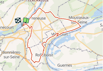
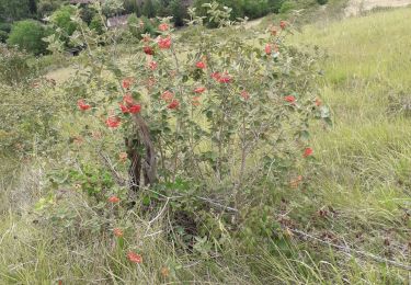
Trail Walking of 19.6 km to be discovered at Ile-de-France, Yvelines, Bonnières-sur-Seine. This trail is proposed by zanogueb.

Description

Entre 2 boucles de la Seine.
Départ parking gare routière.

Elevation profile

Positioning

Country:
France
Region :
Ile-de-France
Department/Province :
Yvelines
Municipality :
Bonnières-sur-Seine
Location:
Unknown
Start:(UTM)
396471 ; 5433018 (31U) N.

Trails nearby

Trail Walking La Roche-Guyon - La Roche Guyon - Chérence - Photo
Walking
marcel.F

Walking

Medium
(1)
La Roche-Guyon, Ile-de-France, Val-d'Oise, France
8.8 km | 11.5 km-effort
2h 30min
Yes
Trail Walking Giverny - 076-104-Giverny Matin 12km-526-030- - Photo
Walking
rvs147

Walking

Easy
(2)
Giverny, Normandy, Eure, France
9.2 km | 11.5 km-effort
2h 32min
Yes
Trail Walking La Roche-Guyon - La Roche-Guyon boucle - Photo
Walking
vincentph

Walking

Easy
(1)
La Roche-Guyon, Ile-de-France, Val-d'Oise, France
15.5 km | 19.5 km-effort
4h 15min
Yes
Trail Walking Guernes - guernes port de l'ilon - Photo
Walking
mictar78

Walking

Very easy
(2)
Guernes, Ile-de-France, Yvelines, France
12.5 km | 13.5 km-effort
2h 48min
Yes
Trail Mountain bike Rolleboise - Rolleboise Giverny - Photo
Mountain bike
francisjames

Mountain bike

Difficult
Rolleboise, Ile-de-France, Yvelines, France
64 km | 79 km-effort
3h 55min
Yes
Trail On foot Gommecourt - Accès gr2 - Photo
On foot
PRO

On foot

Easy
Gommecourt, Ile-de-France, Yvelines, France
5.6 km | 6.7 km-effort
1h 31min
No
Trail Walking Giverny - Giverny Le lézard vert - Photo
Walking
Marie-Claire-mcp

Walking

Difficult
Giverny, Normandy, Eure, France
5.7 km | 7.5 km-effort
1h 57min
No
Trail Walking Giverny - Giverny : les coteaux vers le Vexin 13 km - Photo
Walking
MichelRando7656

Walking

Very easy
Giverny, Normandy, Eure, France
14.7 km | 17.8 km-effort
4h 51min
No
Trail Walking La Roche-Guyon - La Roche Guyon  - Photo
Walking
Marie-Claire-mcp

Walking

Very easy
La Roche-Guyon, Ile-de-France, Val-d'Oise, France
8.6 km | 11.4 km-effort
2h 53min
Yes


Close
My subscriptions