


22/04/2017 Rando Etang d'Artax

chrisbal
User
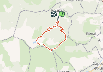

Length
12.2 km

Max alt
1838 m

Uphill gradient
967 m
Km-Effort
25 km

Min alt
913 m

Downhill gradient
974 m
Boucle
Yes
Creation date :
2017-05-25 00:00:00.0
Updated on :
2020-06-15 22:09:55.098
5h04
Difficulty : Difficult

FREE GPS app for hiking
 SityTrail
IGN / Geographical institutes
SityTrail Plus
The world is yours!
About
Trail Walking of 12.2 km to be discovered at Occitania, Ariège, Gourbit. This trail is proposed by chrisbal.
Positioning
Country:
France
Region :
Occitania
Department/Province :
Ariège
Municipality :
Gourbit
Location:
Unknown
Start:(Dec)
Start:(UTM)
380092 ; 4743468 (31T) N.
Comments
Tres belle boucle par beau temps