


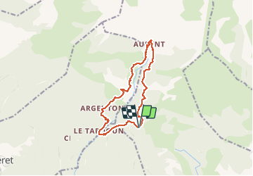
Col du Fam - Aurent - Argenton

GrouGary
User

Length
13.2 km

Max alt
1390 m

Uphill gradient
654 m
Km-Effort
22 km

Min alt
1007 m

Downhill gradient
652 m
Boucle
Yes
Creation date :
2018-04-16 12:45:38.085
Updated on :
2018-04-16 12:45:38.085
4h50
Difficulty : Medium

FREE GPS app for hiking
 SityTrail
IGN / Geographical institutes
SityTrail Plus
The world is yours!
About
Trail Walking of 13.2 km to be discovered at Provence-Alpes-Côte d'Azur, Alpes-de-Haute-Provence, Castellet-lès-Sausses. This trail is proposed by GrouGary.
Description
Circuit en boucle, A/R sur la rivière du Coulomp.
Entre Aurent et Argenton, quelques passages exposés et dangereux sur cône d'éboulis.
Positioning
Country:
France
Region :
Provence-Alpes-Côte d'Azur
Department/Province :
Alpes-de-Haute-Provence
Municipality :
Castellet-lès-Sausses
Location:
Unknown
Start:(Dec)
Start:(UTM)
316746 ; 4876145 (32T) N.
Comments