


tête de vautisse

orsel
User GUIDE
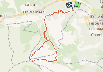

Length
23 km

Max alt
3128 m

Uphill gradient
1849 m
Km-Effort
48 km

Min alt
1635 m

Downhill gradient
1848 m
Boucle
Yes
Creation date :
2017-04-24 00:00:00.0
Updated on :
2017-04-24 00:00:00.0
9h57
Difficulty : Unknown

FREE GPS app for hiking
 SityTrail
IGN / Geographical institutes
SityTrail Plus
The world is yours!
About
Trail Nordic walking of 23 km to be discovered at Provence-Alpes-Côte d'Azur, Hautes-Alpes, Freissinières. This trail is proposed by orsel.
Description
avec Jean etienne
Positioning
Country:
France
Region :
Provence-Alpes-Côte d'Azur
Department/Province :
Hautes-Alpes
Municipality :
Freissinières
Location:
Unknown
Start:(Dec)
Start:(UTM)
305124 ; 4957360 (32T) N.
Comments