


Bagnols en Forêt GR51 new2

Sugg
User
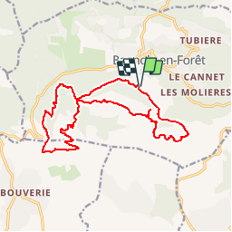

Length
18.1 km

Max alt
419 m

Uphill gradient
629 m
Km-Effort
27 km

Min alt
91 m

Downhill gradient
629 m
Boucle
Yes
Creation date :
2019-03-22 16:58:27.273
Updated on :
2019-03-22 16:58:27.325
6h00
Difficulty : Medium

FREE GPS app for hiking
 SityTrail
IGN / Geographical institutes
SityTrail Plus
The world is yours!
About
Trail Walking of 18.1 km to be discovered at Provence-Alpes-Côte d'Azur, Var, Bagnols-en-Forêt. This trail is proposed by Sugg.
Description
Parcours de rechange ( remplacement de la sortie du 3 mai 2017.
Ceci est une variante un peu plus longue du Bagnols en Forêt GR51 New ) A voir sur place le jour J.
Positioning
Country:
France
Region :
Provence-Alpes-Côte d'Azur
Department/Province :
Var
Municipality :
Bagnols-en-Forêt
Location:
Unknown
Start:(Dec)
Start:(UTM)
313457 ; 4822277 (32T) N.
Comments