


Meriel - Parmain

meillon
User
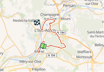

Length
21 km

Max alt
176 m

Uphill gradient
260 m
Km-Effort
25 km

Min alt
22 m

Downhill gradient
271 m
Boucle
No
Creation date :
2018-06-08 00:00:00.0
Updated on :
2018-06-08 00:00:00.0
6h59
Difficulty : Easy

FREE GPS app for hiking
 SityTrail
IGN / Geographical institutes
SityTrail Plus
The world is yours!
About
Trail Walking of 21 km to be discovered at Ile-de-France, Val-d'Oise, Mériel. This trail is proposed by meillon.
Description
Bords de l Oise - forêt de la île Adam -Pavillon chinois-
Positioning
Country:
France
Region :
Ile-de-France
Department/Province :
Val-d'Oise
Municipality :
Mériel
Location:
Unknown
Start:(Dec)
Start:(UTM)
441938 ; 5436347 (31U) N.
Comments
Randonnée superbe créé par Jean pierre Duchange