


67 KLINGENTHAL BARR

LUTZMarc
User
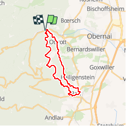

Length
23 km

Max alt
631 m

Uphill gradient
727 m
Km-Effort
33 km

Min alt
195 m

Downhill gradient
730 m
Boucle
Yes
Creation date :
2017-06-07 00:00:00.0
Updated on :
2017-06-07 00:00:00.0
6h59
Difficulty : Medium

FREE GPS app for hiking
 SityTrail
IGN / Geographical institutes
SityTrail Plus
The world is yours!
About
Trail Walking of 23 km to be discovered at Grand Est, Bas-Rhin, Ottrott. This trail is proposed by LUTZMarc.
Description
Belle rando praticable toute l'année.
vitesse moy 4,3 Km/h le matin
Départ à 9h pour être à 12 H au resto L'Esprit Goumand
4 Rue de la Kirneck 67140 Barr
Repas excellent.
Positioning
Country:
France
Region :
Grand Est
Department/Province :
Bas-Rhin
Municipality :
Ottrott
Location:
Unknown
Start:(Dec)
Start:(UTM)
382181 ; 5369432 (32U) N.
Comments