


manon

py.jeannot@free.fr
User
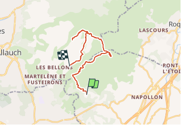

Length
13.6 km

Max alt
692 m

Uphill gradient
573 m
Km-Effort
21 km

Min alt
260 m

Downhill gradient
593 m
Boucle
No
Creation date :
2017-04-28 00:00:00.0
Updated on :
2017-04-28 00:00:00.0
3h59
Difficulty : Unknown

FREE GPS app for hiking
 SityTrail
IGN / Geographical institutes
SityTrail Plus
The world is yours!
About
Trail Other activity of 13.6 km to be discovered at Provence-Alpes-Côte d'Azur, Bouches-du-Rhône, Aubagne. This trail is proposed by py.jeannot@free.fr.
Positioning
Country:
France
Region :
Provence-Alpes-Côte d'Azur
Department/Province :
Bouches-du-Rhône
Municipality :
Aubagne
Location:
Unknown
Start:(Dec)
Start:(UTM)
705716 ; 4798807 (31T) N.
Comments