


madone tutelle 17

barney06
User
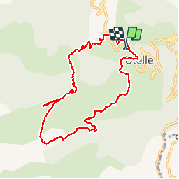

Length
10.9 km

Max alt
1185 m

Uphill gradient
573 m
Km-Effort
18.5 km

Min alt
722 m

Downhill gradient
569 m
Boucle
Yes
Creation date :
2017-04-29 00:00:00.0
Updated on :
2017-04-29 00:00:00.0
6h00
Difficulty : Easy

FREE GPS app for hiking
 SityTrail
IGN / Geographical institutes
SityTrail Plus
The world is yours!
About
Trail Walking of 10.9 km to be discovered at Provence-Alpes-Côte d'Azur, Maritime Alps, Utelle. This trail is proposed by barney06.
Description
rando
Positioning
Country:
France
Region :
Provence-Alpes-Côte d'Azur
Department/Province :
Maritime Alps
Municipality :
Utelle
Location:
Unknown
Start:(Dec)
Start:(UTM)
359025 ; 4864361 (32T) N.
Comments