


la blacherette

bernir
User
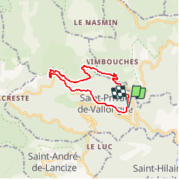

Length
10.7 km

Max alt
780 m

Uphill gradient
292 m
Km-Effort
14.6 km

Min alt
531 m

Downhill gradient
295 m
Boucle
Yes
Creation date :
2017-05-06 00:00:00.0
Updated on :
2017-05-06 00:00:00.0
3h56
Difficulty : Easy

FREE GPS app for hiking
 SityTrail
IGN / Geographical institutes
SityTrail Plus
The world is yours!
About
Trail Walking of 10.7 km to be discovered at Occitania, Lozère, Saint-Privat-de-Vallongue. This trail is proposed by bernir.
Description
de Georges à André
Positioning
Country:
France
Region :
Occitania
Department/Province :
Lozère
Municipality :
Saint-Privat-de-Vallongue
Location:
Unknown
Start:(Dec)
Start:(UTM)
567649 ; 4902997 (31T) N.
Comments