


Arthies3-Villarceaux

dufland
User
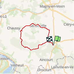

Length
19.5 km

Max alt
212 m

Uphill gradient
378 m
Km-Effort
25 km

Min alt
79 m

Downhill gradient
377 m
Boucle
Yes
Creation date :
2019-04-16 12:59:17.282
Updated on :
2019-04-16 12:59:17.311
5h16
Difficulty : Easy

FREE GPS app for hiking
 SityTrail
IGN / Geographical institutes
SityTrail Plus
The world is yours!
About
Trail Walking of 19.5 km to be discovered at Ile-de-France, Val-d'Oise, Arthies. This trail is proposed by dufland.
Positioning
Country:
France
Region :
Ile-de-France
Department/Province :
Val-d'Oise
Municipality :
Arthies
Location:
Unknown
Start:(Dec)
Start:(UTM)
411620 ; 5438639 (31U) N.
Comments