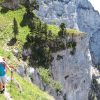
De Pont de Chervil, circuit de Glo, Chalencon, le Vigneron et "Dolce Via"

frizou83
User
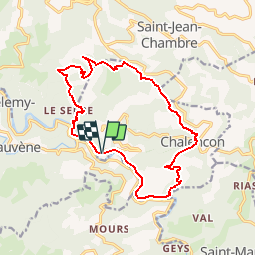

Length
16.2 km

Max alt
870 m

Uphill gradient
708 m
Km-Effort
26 km

Min alt
276 m

Downhill gradient
709 m
Boucle
Yes
Creation date :
2017-05-06 00:00:00.0
Updated on :
2017-05-06 00:00:00.0
5h27
Difficulty : Medium

FREE GPS app for hiking
 SityTrail
IGN / Geographical institutes
SityTrail Plus
The world is yours!
About
Trail Walking of 16.2 km to be discovered at Auvergne-Rhône-Alpes, Ardèche, Chalencon. This trail is proposed by frizou83.
Positioning
Country:
France
Region :
Auvergne-Rhône-Alpes
Department/Province :
Ardèche
Municipality :
Chalencon
Location:
Unknown
Start:(Dec)
Start:(UTM)
621767 ; 4970169 (31T) N.
Comments