


Les ruines du Château de Rochebonne

frizou83
User

Length
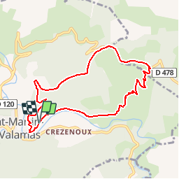
8.5 km

Max alt
893 m

Uphill gradient
400 m
Km-Effort
13.9 km

Min alt
511 m

Downhill gradient
402 m
Boucle
Yes
Creation date :
2017-05-06 00:00:00.0
Updated on :
2017-05-06 00:00:00.0
3h03
Difficulty : Easy

FREE GPS app for hiking
 SityTrail
IGN / Geographical institutes
SityTrail Plus
The world is yours!
About
Trail Walking of 8.5 km to be discovered at Auvergne-Rhône-Alpes, Ardèche, Saint-Martin-de-Valamas. This trail is proposed by frizou83.
Positioning
Country:
France
Region :
Auvergne-Rhône-Alpes
Department/Province :
Ardèche
Municipality :
Saint-Martin-de-Valamas
Location:
Unknown
Start:(Dec)
Start:(UTM)
608543 ; 4976975 (31T) N.
Comments