


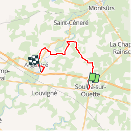
Tour du pays de Laval (Soulgé sur Ouette , Argentré)

Axelloceane
User


3h50
Difficulty : Medium

FREE GPS app for hiking
 SityTrail
IGN / Geographical institutes
SityTrail Plus
The world is yours!
About
Trail Walking of 15.1 km to be discovered at Pays de la Loire, Mayenne, Soulgé-sur-Ouette. This trail is proposed by Axelloceane.
Description
Départ de Soulgé sur Ouette, suivre la route jusqu'au château d'eau,tourner à gauche puis prendre le chemin la Hachellerie à droite et laisser vous guider par le balisage.Passage par le moulin de Montbesnard pour rejoindre le plan d'eau d'Argentré.
Photos
 - Photo 1")
 - Photo 2")
 - Photo 3")
Positioning
Comments